

SnowCPS: Commercial Snow Operations & Real-Time Geofencing Platform
Managing commercial snow and ice operations demands rapid response times, clear liability protection, and coordinated execution across hundreds of properties. SnowCPS is a centralized operations platform that unifies real-time GPS polygon geofencing, weather-triggered route sequencing, and automated field dispatch across internal crews and independent subcontractor networks.
The platform features OpsCore, a federated relay architecture that synchronizes job assignments, live progress, and photo evidence with third-party contractor portals without exposing private profit margins or client contacts. Integrated with QuickBooks Online, it converts verified field runs directly into itemized, audit-ready invoices.
- Industry
- Commercial Property Services
- Technology
- Laravel · Leaflet · Mapbox GL · QuickBooks
- Platform
- Web Operations Suite & Mobile Field App
- Focus
- Field Dispatch, Geofencing & Billing Automation
Business Objective
The primary objectives of the project were to:
- 1Eliminate slip-and-fall liability disputes through GPS perimeter verification and timestamped photos
- 2Deploy a federated contractor network allowing third-party partners to manage jobs in isolated portals
- 3Guarantee uninterrupted field execution on mobile devices during severe blizzard conditions
- 4Automate post-storm billing by converting verified timesheets directly into QuickBooks Online invoices
Key Challenges
Operating winter service fleets during extreme storms presented critical operational, privacy, and legal challenges.
Blizzard Cellular Outages
Plow operators frequently work in severe weather where cellular signal drops or towers become overloaded, risking lost work logs and unrecorded material usage.
Subcontractor Privacy & Isolation
Dispatching work to external contractors required strict partitioning to share property boundaries and hazard notes without revealing client margins or customer billing rates.
Slip-and-Fall Liability Defense
Commercial properties face aggressive litigation. Proving that an entrance, walkway, or fire lane was treated at an exact hour required tamper-proof spatial logging and photo proof.
Multi-Rate Billing Complexity
Service contracts vary widely across fixed per-push rates, equipment hourly charges, sidewalk clearing, and chemical de-icing materials, creating delays in legacy manual billing.
Our Solution
A distributed operations platform was developed around Laravel, interactive geospatial mapping, and a secure partner relay bus that seamlessly connects dispatchers, contractors, field crews, and clients.
Core Solution Highlights
- Interactive polygon mapping for site boundaries, hazard markers, and snow storage zones
- OpsCore partner relay for automated job dispatch and status sync between independent portals
- Rolling offline route cache enabling seamless mobile execution without active cellular data
- Environmental telemetry capture recording temperature, wind speed, rain depth, and snowfall depth per service run
- Dual-tier approval workflows (subcontractor review followed by administrative client sign-off)
- QuickBooks Online synchronization converting approved runs into itemized customer invoices automatically
Platform Architecture & Technology
A modular, event-driven architecture designed for high availability, secure partner integration, and continuous field execution.
Command & Control
Web Operations Suite
- Centralized web application built with Laravel
- Interactive property site plans rendered with Leaflet and Mapbox
- Role-based permission controls separating client, dispatcher, and contractor views
- Supervisor daemon managing background job queues and dispatch notifications
Execution & GPS
Mobile Field Engine
- Token-authenticated mobile API tailored for field plowing and sidewalk teams
- Point-in-polygon geofence validation with configurable tolerance distances
- Rolling offline route cache pre-loading site maps, job notes, and hazard pins
- GPS beacon tracking capturing live worker breadcrumbs and geofence departures
Federated Sync
OpsCore Partner Relay
- Decoupled relay bus linking independent Client and Contractor portal installations
- Cryptographic HMAC request signing with replay protection windows
- Automated property geometry materialization sanitizing sensitive customer details
- QuickBooks Online connector syncing approved timesheets into customer invoices
Storm Planning
Partner Relay
Field Execution
Billing Automation
Storm Planning
Partner Relay
Field Execution
Billing Automation
Technology & Capabilities
Enterprise technologies combined to deliver reliable performance during critical winter weather events.
Backend Platform
Logic & Persistence
- PHP and Laravel web framework
- Relational MySQL database with structured migrations
- Redis and database queues for asynchronous processing
- Supervisor daemon process monitoring for background workers
Geospatial & Interface
Mapping & Dispatch
- Vuexy administration theme on Bootstrap 5
- Leaflet 1.9 and Mapbox GL interactive satellite mapping
- FullCalendar 6 for shift scheduling and recurring storm route views
- DataTables BS5 with server-side pagination and export
OpsCore Federated Relay
Cross-Portal Data Sync
- Cryptographic HMAC payload verification
- Bi-directional outbox and inbox sync queues
- Ephemeral signed media streaming URLs
- Automated retry mechanisms with exponential backoff
Financial Integration
Accounting Bridge
- Intuit QuickBooks Online OAuth API connector
- Bi-directional sync for Customers, Vendors, and Invoices
- Automated token refresh with distributed locks
- Itemized billing conversion from verified field logs
Key Features
Built to solve practical field logistics, legal compliance, and partner management challenges.
Polygon Geofencing & Site Plans
Dispatchers draw custom spatial zones over satellite maps to define clearing areas, fire lanes, and curb hazards, giving field crews clear visual boundaries.
OpsCore Federated Partner Hub
Dispatches jobs to external contractor portals with complete site geometry and instructions while stripping customer identities and private profit margins.
Weather-Triggered Route Sequencing
Configurable storm routing templates adjust to snowfall triggers, allowing dispatchers to dynamically assign multi-worker crews and reorder stops.
Photo Proof & Telemetry Capture
Crews capture before-and-after photos alongside GPS coordinates, ambient temperature, wind speed, rain depth, snowfall depth, and de-icing material quantities per service run.
Dual-Tier Work Approvals
Subcontractor managers verify field submissions before passing them to central client administrators for sign-off, eliminating invoicing disputes.
Automated QuickBooks Invoicing
Reconciles per-push, hourly equipment, and material usage into unbilled ledgers, syncing directly into QuickBooks Online invoices without manual data entry.
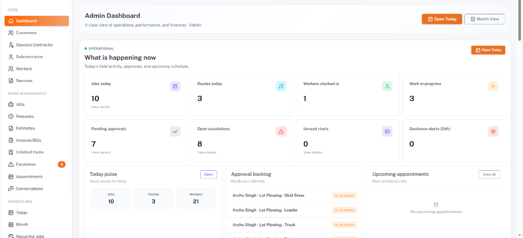
Operations Command
Real-Time Fleet Oversight & Geofence Dispatch Dashboard
A single operational console providing dispatchers and operations teams with complete visibility across property sites, live worker coordinates, storm progress, and pending approvals.
- Dispatch calendar filtering by one-off jobs, appointments, and weather-triggered storm routes
- Color-coded route maps showing live GPS worker coordinates and geofence perimeter exit alerts
- Dual-panel review center for timestamped before-and-after service photo inspection
- Environmental telemetry log capturing temperature, wind speed, rain, and snowfall depth per execution
- Comprehensive audit trail recording every job transition, manual override, and OpsCore sync event
User Experience & Field Usability
Engineered for clarity and ease of use in sub-zero winter environments and fast-paced dispatch bullpens.
- High-contrast color palettes and large touch targets allowing mobile plow operators to log visits with gloves
- Offline-first data caching preventing work loss when crews work in remote commercial lots with weak signal
- Streamlined batch approval workflows enabling supervisors to audit dozens of recurring site visits quickly
- Intuitive map drawing tools with snapping polygon lines for fast, accurate property boundary setup
Results & Operational Impact
Measurable improvements in field accountability, operational velocity, and billing turnaround.
100% Verified
GPS & Photo Proof
Every service visit logs verified GPS coordinates and visual evidence, providing commercial property owners with robust liability defense.
Zero Leakage
Partner Data Isolation
OpsCore structurally removes internal margins and customer contact records before syncing jobs to external subcontractor networks.
Rolling Cache
Offline Route Access
Field crews maintain complete access to route sequences, site plans, and hazard instructions even during widespread cellular outages.
Sub-Minute
Billing Conversion
Approved field runs convert automatically into unbilled accounting ledgers, syncing directly into QuickBooks Online invoices without manual entry.
Frequently asked questions
OpsCore uses an asynchronous cryptographic message bus. Every outbound dispatch payload is signed using HMAC with a shared secret. The receiving portal verifies the signature and validates timestamps against a replay window. Persistent outbox and inbox queues ensure reliable delivery even if a partner portal is temporarily offline.
Still have questions? Email us directly at hello@hexagoninfosoft.com
Planning a complex field logistics or multi-portal platform?
Hexagon Infosoft specializes in engineering high-reliability enterprise platforms, real-time geospatial applications, and secure cross-organization synchronization systems.